
May 8, 2017
At the beginning of the thunderstorm season, the National Weather Service introduced the Traffic Flow Management Convective Forecast (TCF) – a new product that can help business aircraft operators better deal with potential ATC delays caused by thunderstorms.
The TCF is not a flight-planning tool, per se. It was designed to provide ATC with an accurate, high-confidence forecast to help them identify constraints throughout the National Airspace System in a timely fashion and implement any necessary traffic management initiatives quicker. However, operators can use the TCF to anticipate where thunderstorm activity may impact air traffic flows and where traffic management initiatives might be implemented.
The TCF looks like the old Collaborative Decision Making Convective Forecast Product (CCFP). However, the TCF is a high confidence only product. Its graphical representation of forecasted convection meets specific intensity and echo top height criteria. Also, the TCF, unlike the CCFP, displays lines of convection. Here’s how it works:
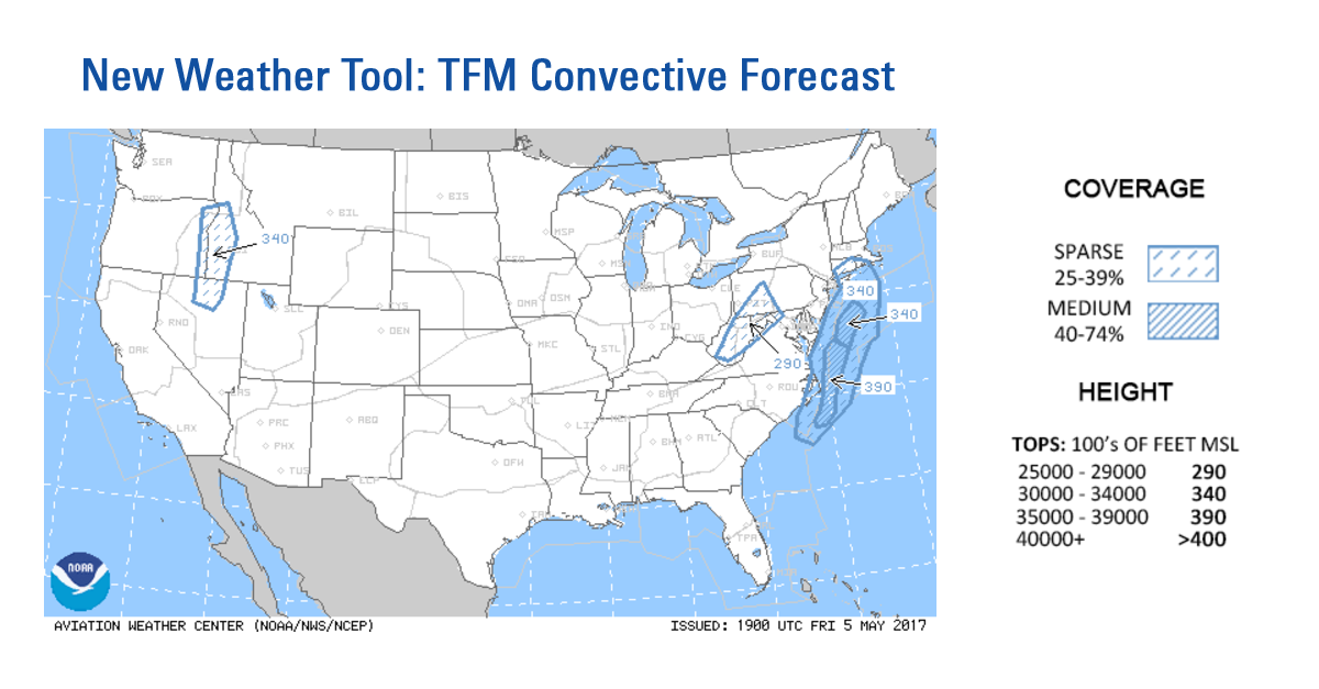
- Areas of convection are identified by blue polygons
- Broken hatching indicates sparse coverage (25-39 percent)
- Striped hatching indicates medium coverage (40-74 percent)
- A convective line of medium coverage (40-74 percent) is displayed as a dashed purple line, meaning a broken line of forecast convection
- A thunderstorm line containing high coverage (75-100 percent) is displayed as a solid purple line, meaning a solid line of forecast thunderstorms
Maximum echo tops, covering at least 25 percent of the area within a polygon, are identified in one of four classes:
- 290 indicates echo tops that are expected to be from 25,000 – 29,000 feet MSL
- 340 indicates echo tops that are expected to be from 30,000 – 34,000 feet MSL
- 390 indicates echo tops that area expected to be from 35,000 – 39,000 feet MSL
- 400 indicates echo tops that are more than 40,000 feet MSL
This greater detail included in TCFs – which are issued every two hours, seven days a week – provides a better picture of likely convective weather trends. So by understanding and studying TCFs, operators can get a better idea of how air traffic managers may deal with thunderstorms. Armed with that knowledge, business aircraft can avoid airspace system constraints that the FAA may impose.
For example, sparse convective coverage may indicate summer “popcorn” storms, which tend to occur throughout a given area, but not along a specific line or frontal boundary. Depending on the location of this coverage, traffic managers may allow enroute controllers to manage deviations tactically by adding a few more miles-in-trail between aircraft.
However, if the sparse area is large and within Washington, Cleveland or New York Center, airspace flow programs may be used to slow down large amounts of traffic by assigning expected departure clearance times. More coverage might warrant a significant route structure to help manage the traffic out of the constrained areas, especially when large metroplexes are on one side of a line or large area of medium coverage.
Download NBAA’s new flight-planning guide at www.nbaa.org/ats.