Scope, as it relates to Traffic Flow Management, can be defined as the range of influence or impact for a particular TMI (delay program, ground stop, etc). Flights falling outside the scope of a TMI will not be affected by that particular initiative. Scope is determined by one of three ways – by distance, by center, or by tier.
Distance
Sometimes the scope for TMIs will be determined by distance from a particular airport. This will be noted under a TMI’s scope as something like “1200 miles+CZY”, meaning that all flights originating from within 1200 miles and Toronto Center (CZY) would be included in the initiative.
Defining scope by distance can be helpful in some situations, giving managers more precise control over what flights will be included in or excluded from a TMI.
Center
The second way that scope can be expressed is by enroute center (ARTCC). When this method is used, the traffic captured in a TMI is specified by which center they are departing from. For example a TMI with a scope of “ZNY+ZDC+ZBW” would capture flights departing from airports within New York Center (ZNY), Washington Center (ZDC), and Boston Center (ZBW).
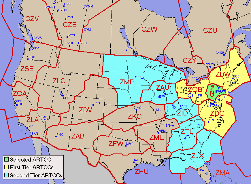
Each enroute center is abbreviated with a 3-letter code, beginning with the letter “Z”. The centers can be seen in the graphic below.
Tiers
A third way that scope can be defined is by tier. The word “tier” describes a geographical area that is based on Air Route Traffic Control Center (ARTCC) boundaries. In essence, tiers are simply groups of multiple enroute centers.
This is best explained using a graphic. In the image below, the ARTCC selected is New York Center (ZNY) – shown in green. The yellow ARTCCs would be considered “First Tier” since they are immediately adjacent to ZNY. The blue ARTCCs are “Second Tier” because they are, in turn, adjacent to the First Tier ARTCCs. This is also sometimes indicated as ZNY2.
Also note that tier information is inclusive, meaning that a Second Tier initiative would also include First Tier centers.
Here is a practical example of how scope would be interpreted:
A Second Tier ground delay program (GDP) for Teterboro, NJ (TEB) has just been implemented. Would a flight leaving from Colorado Springs, CO (COS) be included in the program and issued an EDCT? How about a flight from Minneapolis, MN (MSP)?
- COS is located in Denver Center (ZDV) which does not border either ZNY (where TEB is located) or any of the ZNY First Tier centers. Therefore, the flight would be exempt from the GDP and would not be issued an EDCT.
- MSP is located in Minneapolis Center (ZMP) which is a Second Tier center from ZNY. Therefore, the flight would be caught in the GDP and the flight would likely be issued an EDCT.
There are some variations to the tier description to account for the size and domestic-international services provided by each ARTCC. Here are some additional scope definitions that are used:
- ALL – flights departing from anywhere in the continental US would be captured
- Six West – ZAB / ZDV / ZLA / ZLC / ZOA / ZSE
- Ten West – ZAB / ZDV / ZFW / ZHU / ZKC / ZLA / ZLC / ZMP / ZOA / ZSE
- Twelve West – ZAB / ZAU / ZDV / ZFW / ZHU / ZKC / ZLA / ZLC / ZME / ZMP / ZOA / ZSE
- No West – exclude ZAB / ZDV / ZLA / ZLC / ZOA / ZSE
- Ten East – ZBW, ZNY, ZDC, ZJX, ZMA, ZTL, ZME, ZID, ZAU
More information about tier descriptions can be found on the FAA’s tier map.